Dispersed Camping in Utah: A BLM Land Guide by Region
Dispersed camping in Utah on BLM land — specific areas near all five national parks, desert-specific rules, seasonal windows, and what we learned camping in red rock country.
Utah has five national parks where campgrounds book out months in advance at $30–$50 a night. It also has 22.8 million acres of BLM land — more than any other state — where you can camp for free, tonight, with no reservation. We’ve spent weeks of our lives dispersed camping in Utah, from the red rock corridors outside Moab to the empty badlands around Capitol Reef, and the contrast between a sold-out park campground and a free BLM site ten minutes down the road never stops being absurd.
The catch: desert camping is not mountain camping. There’s no shade, no water, no forgiving weather. Roads dissolve in rain. Summer heat can be genuinely dangerous. Whether you call it dispersed camping or boondocking, Utah has more free camping on public land than any other state. This guide covers the BLM areas worth knowing, organized by which national park they’re closest to, along with the desert-specific preparation that most guides skip entirely. If you’re new to dispersed camping, start with our complete dispersed camping guide for the full breakdown on rules, gear, and how to find sites. This article assumes you know the basics and want to know where to go in Utah.
Utah BLM Camping Rules — What You Need to Know
The general BLM dispersed camping rules apply across Utah — 14-day stay limit, camp on previously disturbed ground, pack everything out. We cover all of that in our dispersed camping guide. But Utah has a few wrinkles worth understanding before you drive in.
The Basics (and What Changes by Field Office)
Utah’s BLM land is managed by six field offices: Moab, Monticello, Vernal, Richfield, Fillmore, and St. George. Each manages its land differently. The Moab Field Office has designated camping corridors with specific boundaries and sometimes fees. The Richfield office manages the San Rafael Swell with a lighter touch. St. George oversees areas near Zion with tighter restrictions near the park boundary.
The field office website is your authoritative source for Utah dispersed camping rules in any given area. If you’re not sure which office manages the land you’re heading to, the BLM Utah website has an interactive map that shows boundaries.
Designated vs. Open BLM Land
This is the distinction that catches people near Moab. Some BLM areas in Utah have been formally designated with numbered campsites, fire rings, and — increasingly — fees. The UT-128 corridor east of Moab and the UT-313 corridor toward Canyonlands Island in the Sky are the biggest examples. These designated sites run $15–$20 per night in peak season.
Beyond the designated corridors, most BLM land in Utah is open to standard dispersed camping — no fee, no reservation, no numbered site. You pull off on a previously disturbed area and set up. Knowing which category you’re in before you arrive saves you from an unexpected fee or a ranger conversation.
Utah State Trust Land (SITLA)
The Best BLM Areas for Dispersed Camping in Utah
We’ve camped in five distinct BLM regions across Utah. Here’s the quick reference, organized by the nearest national park:
- Near Moab (Arches & Canyonlands) — Most popular, most crowded, some designated sites now charge fees
- Near Capitol Reef — Quiet, vast, colorful badlands and desert, least-visited park zone
- Near Zion & Bryce — Limited BLM near Zion, but Grand Staircase-Escalante opens up huge territory
- San Rafael Swell (near Goblin Valley) — Underrated, dramatic geology, almost no crowds
- Vernal & Uinta Basin — Northern Utah alternative, cooler summers, very few people
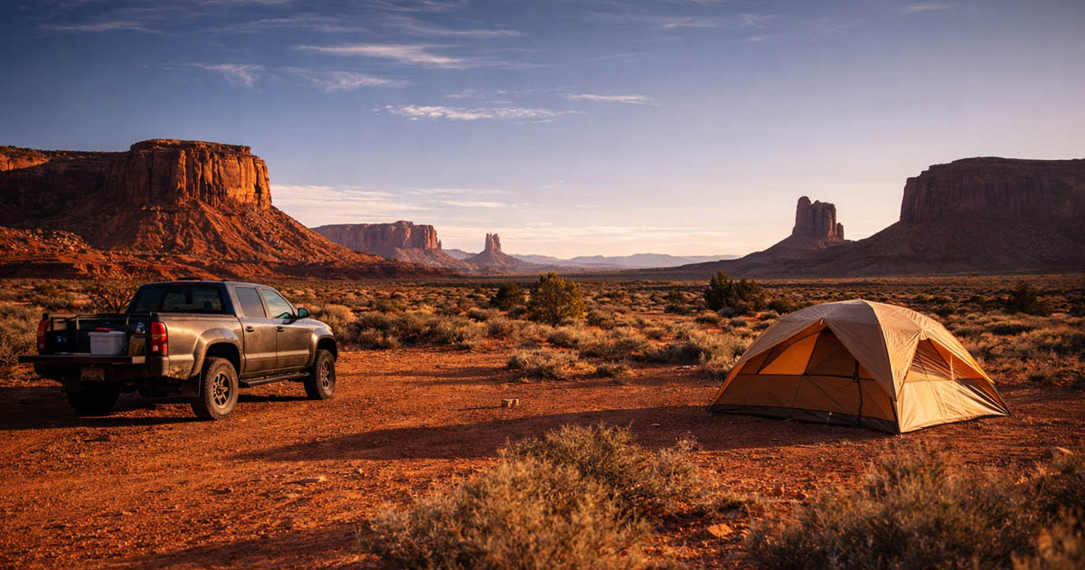
Near Moab — Arches & Canyonlands
If you’re looking for dispersed camping near Moab, you’re not alone — Moab is ground zero for BLM camping in Utah, and it shows. The BLM areas closest to town have been discovered, designated, and in many cases, monetized. But there’s still free camping if you know where to look and when to arrive.
Designated areas (fees apply): The UT-128 corridor along the Colorado River east of Moab has numbered sites with fire rings. Peak season fees run $15–$20 per night — still cheaper than the park, but not free. The UT-313 corridor toward Canyonlands Island in the Sky has similar designated sites. Both corridors fill up by early afternoon on spring and fall weekends.
Free dispersed camping: Willow Springs Road north of Moab has open BLM pulloffs with no fees. Kane Creek Road southwest of town starts paved and transitions to dirt with dispersed sites along the canyon. BLM land south of Moab along US-191 toward Monticello has scattered pulloffs, though they’re less scenic than the river corridors. For more solitude, the Lockhart Basin Road south of the UT-313 junction drops into remote BLM territory — high clearance required, and you’ll be alone.
Crowding reality: Spring (March–May) and fall (September–October) weekends are packed. We’ve arrived at 2 PM on a March Saturday and driven past 30 occupied sites before finding an open pulloff on Willow Springs Road. Midweek is a different world — the same road had three occupied sites on a Tuesday. If you’re visiting Moab on a weekend in season, arrive before noon or have backup areas identified.
Cell signal: Decent within a few miles of Moab. Drops to nothing on the UT-128 corridor past mile 15. Gone entirely on Lockhart Basin and most backcountry roads.
Near Capitol Reef
Dispersed camping near Capitol Reef is some of the best in the state. It’s the least-visited of Utah’s Big 5, and the surrounding BLM land reflects that quiet. We’ve camped here four times and had neighbors exactly once.
Where to look: The BLM land along UT-24 east of the park toward Hanksville is wide-open desert with pulloffs offering views of colorful badlands. The Factory Butte area — a stark, moon-like landscape visible from miles away — has established dispersed sites on BLM land accessed from dirt roads off UT-24. South of the park, the Notom Road corridor runs along the Waterpocket Fold with scattered BLM pulloffs. For the adventurous, the Cathedral Valley approach roads (Hartnet Road from the north, Caineville Wash Road from the east) cross BLM land with dispersed camping options before entering the park.
Terrain and access: UT-24 corridor sites are accessible to any vehicle from paved pulloffs. Factory Butte and the dirt roads off UT-24 require high clearance when dry and should not be attempted when wet — the clay soil here is some of the worst in Utah. The Cathedral Valley roads are high-clearance-only in all conditions, and the Fremont River crossing on Caineville Wash Road can be impassable after rain. Notom Road is maintained gravel for the first 15 miles, then degrades.
Crowding reality: Almost nonexistent. Factory Butte has become more popular with photographers, but the camping area is vast enough that neighbors are rare. The Notom Road corridor is empty most of the time. We camped off Hartnet Road on an October weekend and saw one other vehicle in two days.
Cell signal: Essentially none. Torrey and Bicknell have service. Once you head east toward Hanksville or south on Notom Road, you’re off the grid. Satellite communicator is essential here.
Personal note: The night sky at Factory Butte is the darkest we’ve experienced in the lower 48. No trees, no light pollution, no ambient glow on any horizon. If you have even a passing interest in stargazing, this is the spot.
Near Zion & Bryce Canyon
Dispersed camping near Zion is the hardest find in Utah. The park is surrounded by a patchwork of private land, small towns, and limited BLM parcels. Bryce is slightly better, and the real story is Grand Staircase-Escalante National Monument — the vast BLM-managed landscape east of both parks.
Near Zion: Smithsonian Butte Road, accessed from UT-59 south of the park near Rockville, is the most well-known free camping option. BLM pulloffs along this dirt road offer views of Zion’s southern cliffs. It’s a good site — and everyone knows it. Spring and fall weekends, every pulloff is taken by mid-morning. Arrive Friday morning or try midweek. The road is usually passable in 2WD when dry but has some rough spots.
Near Bryce: BLM options directly adjacent to Bryce are limited. The better play is heading east on UT-12 toward Escalante, where Grand Staircase-Escalante National Monument begins. This is BLM-managed land with extensive dispersed camping.
Grand Staircase-Escalante (GSENM): This is the real answer for free camping near both Zion and Bryce. Hole-in-the-Rock Road south of Escalante is a 57-mile dirt road with established dispersed pulloffs along its entire length. The first 10 miles are accessible to most vehicles; beyond that, high clearance is recommended. Cottonwood Canyon Road between UT-12 and US-89 cuts through the monument with dispersed camping options. The Smoky Mountain Road area offers more remote sites.
Cell signal: No signal on Smithsonian Butte. No signal anywhere in GSENM. Escalante and Kanab have service. Plan accordingly.
Near Goblin Valley & the San Rafael Swell
The San Rafael Swell is one of Utah’s best dispersed camping zones — a massive uplift of desert rock, slot canyons, and painted badlands managed by the BLM Richfield Field Office. It’s bisected by I-70, making it surprisingly accessible despite feeling completely remote.
Where to look: The Temple Mountain area south of I-70 (exit 131) has established dispersed sites on BLM land with views of the reef. Goblin Valley Road has BLM pulloffs before you reach the state park entrance. Buckhorn Wash Road runs through a dramatic canyon with petroglyph panels and dispersed camping along its length — accessible to most vehicles when dry. The Wedge Overlook Road leads to the “Little Grand Canyon” of the San Rafael River with BLM camping right at the rim. Wild Horse Road near Goblin Valley accesses slot canyons and open BLM desert.
Crowding reality: Outside of Goblin Valley State Park itself, the Swell is uncrowded. Buckhorn Wash and Wedge Overlook see some weekend traffic, but nothing like Moab. Temple Mountain and the roads south of I-70 are often empty. We spent a full week in the Swell in April and saw other campers on three of seven nights.
Access: Temple Mountain Road, Buckhorn Wash, and Wedge Overlook Road are all passable in 2WD when dry. Wild Horse Road and some spur roads require high clearance. The same clay road warning applies here — any rain shuts down unpaved access.
Cell signal: I-70 corridor has intermittent signal. Once you’re off the highway and into the Swell, expect nothing. The Temple Mountain area and Wedge Overlook have no signal.
Near Vernal & the Uinta Basin
Northern Utah’s BLM option is different from the red rock south — higher elevation, more vegetation, and critically, cooler summer temperatures. When southern Utah is 108°F in July, the Uinta Basin might be 90°F.
Where to look: BLM land near Red Fleet State Park and Steinaker Reservoir northeast of Vernal has accessible dispersed sites. Browns Park along the Green River near the Colorado border is remote and scenic — the terrain transitions from desert to riparian corridor. The Nine Mile Canyon access roads cross BLM land with dispersed options, though the canyon itself is known more for rock art than camping. The Book Cliffs region north of I-70 offers vast, empty BLM territory for those with high-clearance vehicles and a taste for solitude.
Crowding: Minimal. Vernal is not a tourist destination on the level of Moab or the national parks. The BLM land here is used primarily by hunters in fall and OHV riders.
Season: This is the summer alternative. While we wouldn’t recommend southern Utah BLM camping from June through August, the Uinta Basin is manageable. Spring and fall are pleasant. Winter brings snow at higher elevations.
Cell signal: Decent near Vernal. Drops in Browns Park and the Book Cliffs. Nine Mile Canyon has no signal.
Desert Camping in Utah — What’s Different
Mountain dispersed camping and desert BLM camping share rules but not reality. Everything below applies to Utah specifically, and skipping any of it can turn a great trip into a dangerous one.
Water — The Desert Math
Budget 1.5 gallons per person per day minimum in desert conditions. In summer heat or wind — and Utah gets both — bump that to 2 gallons. Wind dehydrates faster than most people realize, and the dry desert air pulls moisture from you even when you don’t feel yourself sweating. For a two-person, three-day trip, you’re carrying 9–12 gallons of water. That’s 75–100 pounds. Plan for it.
We ran short once on a four-day trip in the San Rafael Swell — we’d budgeted 1 gallon per person per day, the wind picked up on day two, and by day three we were rationing. The nearest water was Hanksville, 45 miles of dirt road away. We cut the trip a day short. Lesson learned.
Heat, Cold, and When to Go
The shoulder months — March, April, October, November — are the sweet spot. May and September are also good but increasingly hot (May) or getting cold at night (late September). We’ve camped in southern Utah in every month except July and August, and even early June was pushing it — 98°F at 3 PM with no shade.
Roads That Disappear When Wet
This deserves its own section because it’s the single biggest danger in Utah BLM camping that nobody talks about adequately.
Utah’s desert roads are built on bentonite clay. When dry, they’re firm, smooth, and drivable. When wet, the clay absorbs water and becomes a frictionless surface that cakes on tires in thick layers. You don’t slide gradually — you lose all traction instantly. 4WD doesn’t help. Aggressive tires don’t help. The only thing that helps is not being on the road.
We’ve seen it firsthand: a rainstorm hit while we were camped off Hole-in-the-Rock Road. The road went from dry and firm to impassable in 30 minutes. We waited 36 hours for it to dry enough to drive out. Other campers we talked to had similar stories — one couple in a rental SUV was stuck for two days near Factory Butte.
The rule: Check the weather forecast for the full duration of your trip plus one extra day. If there’s meaningful rain in the forecast, either change your plans to paved-road camping or don’t go. This isn’t overly cautious — it’s the reality of desert clay.
Power and Communication in the Desert
The desert is actually better for solar charging than the mountains — no tree canopy, long sun hours, and intense UV. A portable power station with a solar panel is the ideal desert camping setup. We run a 100W panel that fully charges our station by early afternoon most days. For specifics on what we use, see our guide to the best power stations for dispersed camping.
Cell signal across Utah’s BLM land ranges from weak to nonexistent. The towns have service. The desert between them doesn’t. A satellite communicator — Garmin inReach or Zoleo — is not optional for remote Utah BLM camping. We carry one on every desert trip.
The Bottom Line
Utah’s BLM land is the best free camping near major national parks in the country. Every park in the Big 5 has BLM camping within 30 minutes of the entrance — some within sight of the park boundary. The desert demands more preparation than mountain camping — more water, more awareness of weather and roads, a genuine respect for heat and distance — but the payoff is camping in landscapes that rival the parks, for free, with space to yourself.
If you’re planning a Utah park trip, start here: pick one park, find the BLM areas listed above, check road conditions with the local field office, load up on water at the last town, and camp your first night outside the park rather than inside. You’ll spend $0 instead of $50, and the site might be better.
For readers also exploring dispersed camping in Colorado, the two states complement each other — Colorado for mountain forests, Utah for desert BLM. Different terrain, different seasons, same freedom.
Frequently Asked Questions
Where can you dispersed camp in Utah?
On most BLM land across the state, unless posted otherwise. Utah has 22.8 million acres of BLM land, concentrated in the southern and eastern parts of the state. Some areas near national parks have designated camping zones with specific rules and sometimes fees. Check the local BLM field office for the area you’re visiting.
Is dispersed camping legal in Utah?
Yes, on BLM and most National Forest land. Some BLM areas near Moab and the national parks have designated camping zones with boundaries and fees. It’s not allowed in national parks without a backcountry permit. Check the specific BLM field office — Moab, Richfield, St. George, Vernal, Monticello, or Fillmore — for rules in your area.
Can you camp anywhere on BLM land in Utah?
Generally yes, with exceptions. You must camp on previously disturbed ground, observe the 14-day stay limit, and follow fire restrictions. Some BLM areas near national parks have designated camping corridors, and some now charge fees. Not all BLM roads are open to vehicles — check the BLM travel management map for the area.
Where is free camping near Moab?
BLM land surrounds Moab in every direction. The UT-128 and UT-313 corridors have designated sites, but many now charge fees ($15–$20/night). For free dispersed camping, look at Willow Springs Road, Kane Creek area, and BLM land south of Moab along US-191. Arrive early on spring and fall weekends — sites fill fast.
Can you camp near Zion National Park for free?
Yes, but options are more limited than near other Utah parks. Smithsonian Butte Road south of Zion has BLM dispersed sites, but it’s well-known and fills quickly in season. The Grand Staircase-Escalante National Monument east of Zion and Bryce has vast free camping along Hole-in-the-Rock Road and other corridors — but check road conditions first.
How long can you camp on BLM land in Utah?
The standard limit is 14 days within any 28-day period. After 14 days, you must move at least 25 miles. Some designated camping areas near Moab have shorter limits — check the specific area’s posted rules.
Do you need a permit to camp on BLM land in Utah?
No permit is required for most dispersed camping on BLM land in Utah. Some designated camping areas near national parks charge a fee. A few special recreation management areas require permits — check with the local BLM field office before your trip.