Best Dispersed Camping in Colorado: A Forest-by-Forest Guide
Dispersed camping in Colorado broken down by national forest — with specific roads, seasonal windows, crowding reality, and what we've learned camping in each area.
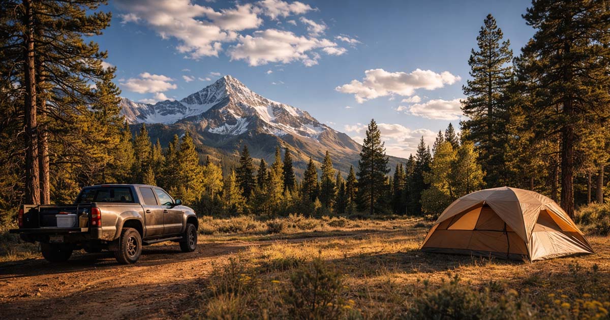
Colorado has 11 national forests, millions of acres of BLM land, and more free camping than you could cover in a decade. We’ve been working on it for years — camping across the San Juan, Uncompahgre, White River, and Grand Mesa — and we’ve barely scratched it. The problem isn’t finding places to go. The problem is that half of it is buried under snow until June, and the other half is packed with Subarus every weekend from July through September.
This guide breaks down dispersed camping in Colorado forest by forest, organized by drive time from Denver, so you can pick the right area for the right trip. Whether you call it dispersed camping or Colorado boondocking, this covers the same thing — free camping on public land with no hookups, no fees, and no reservations. If you’re new to the concept entirely, start with our complete dispersed camping guide for the full breakdown on rules, gear, and finding sites. This article assumes you know the basics and want to know where to go in Colorado specifically.
Colorado Dispersed Camping Rules — What’s Different Here
The general dispersed camping rules — 14-day stay limits, water setbacks, Leave No Trace — apply across Colorado. We cover all of that in our dispersed camping guide. But Colorado has state-specific dispersed camping rules that catch people off guard.
Forest-Specific Orders Matter
Colorado’s 11 national forests each publish their own forest order governing dispersed camping. These orders set the rules that go beyond the federal baseline, and they vary more than you’d expect:
- Arapaho & Roosevelt requires camping within one vehicle length of the road in most areas. You can’t drive 200 feet into a meadow to find a flat spot.
- White River allows camping within 300 feet of a designated road but prohibits camping within a half mile of a developed campground.
- San Juan is generally more permissive but has specific closures around popular trailheads and recreation areas.
The Motor Vehicle Use Map (MVUM) for each forest shows where you can legally drive and camp. Download the MVUM before every trip — it’s free on each forest’s USFS website.
Colorado State Trust Land — Don’t Even Try
This is the most common Colorado-specific mistake we see. Someone checks their Gaia GPS, sees the land isn’t private, and assumes it’s fair game. In many Western states, state trust land allows recreation with a permit. Not in Colorado.
Fire Restrictions and the Colorado Wildfire Season
Colorado’s fire restriction season typically runs June through September, but it shifts by forest and by year. The Western Slope forests — Grand Mesa, Uncompahgre, San Juan — often hit Stage 2 restrictions by mid-July, banning all open flames including camp stoves in some cases.
Before every trip, check fire restrictions for the specific forest you’re visiting. The process: go to the forest’s USFS website, find “Alerts & Notices” or “Fire Information,” and look for the current fire restriction order. It will specify the stage and exactly what’s banned. Restrictions can change mid-trip — we’ve driven into a forest under no restrictions and driven out three days later under Stage 2.
The Best National Forests for Dispersed Camping in Colorado
We’ve camped in six of Colorado’s national forests extensively enough to write about them honestly. Here’s the quick reference, organized by drive time from Denver:
- Arapaho & Roosevelt (1.5–2.5 hrs) — Closest to the Front Range, most crowded on weekends, solid for midweek trips
- Pike & San Isabel (2–3 hrs) — The Arkansas River corridor sweet spot, more room than A&R
- White River (2–3 hrs) — I-70 corridor access, heavily used near the highway, better farther in
- Grand Mesa (4 hrs) — Underrated, uncrowded, flat-top mesa with 300+ lakes
- Uncompahgre (5–6 hrs) — Dramatic San Juan terrain, short season, worth a long weekend
- San Juan (5–6 hrs) — Colorado’s largest forest, diverse terrain, year-round options at lower elevations
Arapaho & Roosevelt National Forests (1.5–2.5 hrs from Denver)
The closest dispersed camping to Denver and the entire Front Range — which is exactly why it’s the hardest place to find an open site on a summer weekend. If you’re searching for dispersed camping near Denver, this is where you’ll start. We’ve camped here a dozen times, and every good experience has been midweek or in September.
Where to look: The best dispersed corridors are along FR-118 south of Guanella Pass, the forest roads around Red Feather Lakes north of Fort Collins, and the roads near Peaceful Valley off CO-72. The Brainard Lake area has a recreation fee zone and limited dispersed options — check the specific restrictions before driving in.
Elevation and season: Most dispersed sites sit between 8,500 and 10,500 feet. Forest roads typically open late May and close with the first heavy snow in October or November. Guanella Pass road (the paved part) stays open longer, but the dispersed spur roads off it are snow-dependent.
Crowding reality: Be honest with yourself. On a Friday afternoon in July, every pulloff along FR-118 near Guanella Pass will be occupied by 4 PM. Red Feather Lakes is slightly better because it’s farther from Denver, but still busy on summer weekends. This forest is best for Tuesday-through-Thursday trips, or shoulder season (late May, late September) when the crowds thin out but the roads are still open.
Cell signal: Variable. You’ll have decent signal near the highways (CO-103, CO-72), but it drops to nothing within a few miles on forest roads. Don’t count on it for navigation — bring the MVUM printed.
Pike & San Isabel National Forests (2–3 hrs from Denver)
The Arkansas River corridor — Buena Vista, Salida, and the Collegiate Peaks area — is where a lot of Front Range dispersed campers end up, and for good reason. It’s far enough to feel like a real trip, close enough for a weekend, and has more room to spread out than Arapaho-Roosevelt.
Where to look: The Cottonwood Pass road (CR-306) west of Buena Vista has dispersed corridors along its forest road spurs. FR-344 and FR-345 in the Chalk Creek area south of BV are reliable options with multiple established sites. Near Salida, the forest roads off US-285 toward Poncha Pass spread camping across a wider area. From Colorado Springs, Rampart Range Road (FR-300) offers dispersed sites within 45 minutes.
Elevation and season: The BV/Salida area sits around 8,000–10,000 feet, with Cottonwood Pass topping out above 12,000. Lower-elevation sites along the Arkansas open by mid-May. The Cottonwood Pass road and higher spurs may not open until mid-June. Rampart Range Road is lower (7,500–9,500 ft) and typically accessible from late April.
Crowding reality: Buena Vista has become a destination town. The closest forest roads to BV — especially along Cottonwood Pass — fill up on summer weekends. But there’s depth here. Move past the first two or three spur roads and the sites thin out significantly. The Chalk Creek area and the roads south of BV toward Poncha Pass are consistently less crowded. We’ve found open sites on July weekends by simply driving 20 minutes farther than most people bother.
Cell signal: Decent in the Arkansas valley itself. Drops to spotty on forest roads. Gone entirely past the first few miles of Cottonwood Pass.
Note: The Collegiate Peaks Wilderness boundary is nearby. Wilderness areas do not allow motor vehicles — so if you cross a wilderness boundary sign, you’re hiking from there. Check the MVUM to see where forest roads end and wilderness begins.
White River National Forest (2–3 hrs from Denver)
White River covers the I-70 corridor from Dillon to Glenwood Springs — Vail, Beaver Creek, Aspen. It’s one of the most-visited forests in the country, and the dispersed camping reflects that. The sites closest to I-70 are heavily used. The ones farther in are worth the extra drive.
Where to look: The Sweetwater area (off I-70 near Dotsero) has dispersed corridors along several forest roads with less traffic than the Vail-area options. The Sylvan Lake road south of Eagle is a favorite — FR-400 and its spurs have established dispersed sites in spruce-fir forest. Near Glenwood Springs, forest roads off the Flat Tops Scenic Byway open up good dispersed territory at higher elevations. We had a Fourth of July camp off FR-600 near Eagle that the pillar mentions — it took four tries to find an open spot, but the spur roads deeper in were empty while the first pulloffs were packed.
Elevation and season: Most dispersed sites range from 8,000 to 10,500 feet. Snow keeps the higher roads closed into June. The Sylvan Lake road and Sweetwater area typically open by late May at their lower ends, with full access by mid-June. Flat Tops area roads can be snow-covered into early July in heavy snow years.
Crowding reality: The I-70 corridor is a double-edged sword. Easy access from Denver means high weekend use on any forest road within 30 minutes of an exit. Sweetwater and the Eagle-area roads are less saturated than the Summit County side. Get at least 45 minutes off the highway and you’ll find manageable crowding even on weekends.
Cell signal: Strong near I-70. Drops quickly in side valleys. The Sylvan Lake road loses signal about 3 miles in. Sweetwater area has no reliable signal once you leave the highway corridor.
Note: The Maroon Bells area near Aspen has specific restrictions and vehicle reservation requirements. It is not a dispersed camping area. Wilderness boundaries are also frequent in White River — check the MVUM carefully.
Grand Mesa National Forest (4 hrs from Denver)
Grand Mesa is the world’s largest flat-top mountain — a 10,000-foot plateau covered in aspen groves, spruce forest, and over 300 lakes. It’s unlike any other dispersed camping in Colorado. The terrain is flat enough that almost any pulloff works as a site, the lakes offer fishing within walking distance of camp, and on a weekday in September, you might not see another person.
Where to look: Most dispersed camping happens along the forest roads branching off CO-65, the Grand Mesa Scenic Byway. The Land O’ Lakes area on the eastern side of the mesa has dozens of established pulloffs along FR-121 and its spurs. Buzzard Creek Road on the north side drops in elevation and offers drier, more open terrain. FR-252 and FR-257 south of the main highway have sites with lake access.
Elevation and season: The mesa top sits around 10,000–11,000 feet. The season is short — CO-65 typically opens in early June and the first big snow can hit by mid-October. Some years the road doesn’t fully clear until late June. Lower-elevation roads on the mesa’s flanks open earlier.
Crowding reality: This is the least crowded forest on this list. We’ve camped on Grand Mesa on three summer weekends and found open sites without trying. The distance from Denver filters out the casual crowd. Grand Junction is only an hour away, but the Grand Junction camping crowd tends toward the desert BLM land rather than the mesa.
Cell signal: Mostly nonexistent on the mesa top. We had zero bars across three days on FR-121. If you need to communicate, drive back to CO-65 near the visitor center area where you might get a weak signal. A satellite communicator is recommended here.
Uncompahgre National Forest (5–6 hrs from Denver)
The Uncompahgre covers the San Juan Mountains around Ouray, Telluride, and Ridgway. This is the Colorado dispersed camping that shows up on Instagram — 13,000-foot peaks, alpine meadows, and forest roads carved into mountainsides. It’s worth the drive, but respect the terrain and the short season.
Where to look: Last Dollar Road (FR-638) between Telluride and Ridgway has pulloffs with views of the Sneffels Range that you won’t forget. Owl Creek Pass (FR-858) east of Ridgway climbs through aspen forests with established dispersed sites at every wide spot. The forest roads around Ridgway Reservoir offer lower-elevation options (7,500–8,500 ft) accessible earlier in the season. For the experienced: the Alpine Loop (Engineer Pass, Cinnamon Pass) has dispersed sites above 11,000 feet — but requires high-clearance 4WD and is not for the unprepared.
Elevation and season: Most sites range from 8,000 to 11,000 feet, with Alpine Loop access above 12,000. The season is short — late June through mid-September for high-elevation roads. Last Dollar Road and Owl Creek Pass typically open in late June and close with September or October snow. The Ridgway area roads below 9,000 feet may be accessible from mid-May.
Crowding reality: Less crowded than anything within three hours of Denver, but not empty. Last Dollar Road fills up on peak summer weekends — it’s too well-known. Owl Creek Pass is consistently less busy. The forest roads south of Ridgway off US-550 are the sleeper option — fewer people, reliable sites, beautiful aspens. We’ve had Owl Creek Pass sites entirely to ourselves on August weekdays.
Cell signal: Limited to nonexistent in most areas. Ridgway and Ouray have service, but once you’re on forest roads, plan on no signal. We carry a Garmin inReach every time we camp in the Uncompahgre.
4WD notes: Last Dollar Road and Owl Creek Pass are passable in a standard SUV or truck with decent clearance in dry conditions. Don’t attempt them in a sedan. The Alpine Loop requires true 4WD with low range — it’s a Jeep trail, not a forest road.
San Juan National Forest (5–6 hrs from Denver)
Colorado’s largest national forest — 1.8 million acres spanning the entire southwest corner of the state. The San Juan is where we’ve spent the most time, and it’s the forest we keep going back to. The terrain ranges from desert canyons at 6,000 feet to alpine peaks above 14,000, which means you can find open dispersed sites nearly year-round if you know where to look.
Where to look: The Piedra River corridor along FR-631 is our favorite dispersed area in Colorado — ponderosa pine forest, river access, established sites that are rarely full. North of Durango, the forest roads off CR-250 toward Vallecito Reservoir spread out into mixed conifer forest with good dispersed corridors. The Chimney Rock area east of Pagosa Springs has lower-elevation sites (6,500–7,500 ft) accessible from April through November. West of Durango, the La Plata Canyon road (CR-124) climbs steeply with dispersed pulloffs along the creek.
Elevation and season: This is the key differentiator. The San Juan’s lower-elevation areas — Chimney Rock, lower Piedra corridor, the Pagosa Springs side — sit between 6,000 and 8,000 feet. Snow clears from these areas by April, and they’re often accessible into late November. Higher-elevation areas (Vallecito at 8,000 ft, La Plata Canyon above 9,000 ft) follow the more typical June-through-October window.
Crowding reality: The San Juan is five to six hours from Denver, and it shows. Even on peak summer weekends, the Piedra corridor has had open sites every time we’ve visited. Vallecito gets busier — it’s a popular area for Durango locals — but the forest roads beyond the reservoir thin out quickly. The Chimney Rock area is almost always quiet.
Cell signal: Spotty throughout. Durango and Pagosa Springs have full service. The Piedra corridor has no signal. Vallecito area gets a weak signal at the reservoir but nothing beyond it. Satellite communicator recommended.
Personal note: The first time we tried dispersed camping was in the San Juan, parked too close to a creek, and got moved by a ranger at dawn. We’ve been back a dozen times since. The Piedra River area in late September — after the summer crowds leave but before the snow — is the best dispersed camping we’ve done anywhere.
Colorado BLM Land — The Other Option
National forests aren’t the only game. Colorado has significant BLM land, primarily on the Western Slope, and it offers a completely different dispersed camping experience — desert terrain, canyon country, less tree cover, wider open views.
Key areas: The Gunnison Gorge National Conservation Area near Montrose has designated camping areas along the river with permit requirements — check the BLM Uncompahgre Field Office. McInnis Canyons near Grand Junction offers desert canyon camping with no permit required. The North Sand Hills near Walden are unique — sand dunes surrounded by sagebrush, popular with OHV users but also good for camping. The San Luis Valley has vast BLM acreage near the Great Sand Dunes, though much of the valley floor is private ranch land — verify ownership carefully.
The rules for Colorado BLM land camping follow the standard BLM framework — 14-day stay limit, camp on previously disturbed ground, and check with the local field office. But the checkerboard ownership pattern on the Western Slope means BLM and private land alternate in ways that aren’t obvious from the road. Use a public land layer on Gaia GPS or onX before setting up. For the full breakdown on BLM dispersed camping rules, see our dispersed camping guide.
The Bottom Line
Colorado has more dispersed camping than you’ll ever use. The real skill isn’t finding a spot — it’s matching the right forest to your timing, your vehicle, and your tolerance for crowding.
If you’re on the Front Range and have never done this, start with Pike & San Isabel on a midweek night. The Chalk Creek area south of Buena Vista is forgiving terrain with reliable sites. Download the Pike-San Isabel MVUM, pick a forest road, and go for one night.
If you have a long weekend, drive to Grand Mesa or Uncompahgre. The extra distance filters out the crowds, and the camping is worth the drive.
If you have a week, head to the San Juan. Camp the Piedra corridor, then move to Vallecito, then drop to Chimney Rock for a lower-elevation night. You’ll see three different ecosystems in three camps.
Whatever you pick, download the MVUM, check fire restrictions, and bring more water than you think you need. For power and gear for extended dispersed trips, we’ve tested the options — see our guide to the best power stations for dispersed camping.
Frequently Asked Questions
Where can you dispersed camp in Colorado?
On most National Forest and BLM land in Colorado, unless posted otherwise. Colorado has 11 national forests and millions of acres of BLM land, primarily on the Western Slope. Each forest has its own rules governed by forest-specific orders — check the Motor Vehicle Use Map (MVUM) for the forest you’re visiting to find legal dispersed corridors.
Is dispersed camping legal in Colorado?
Yes, on National Forest and BLM land. It is not legal on Colorado state trust land, in national parks (Rocky Mountain, Black Canyon, Mesa Verde, Great Sand Dunes), or on private land without permission. Rules vary by forest — always check the local ranger district for current restrictions.
Do you need a permit for dispersed camping in Colorado?
No permit is required for dispersed camping on most National Forest and BLM land in Colorado. Some specific areas near popular recreation zones have seasonal permit requirements or closures — the Brainard Lake area in Arapaho & Roosevelt is one example. Check the ranger district website for the forest you’re visiting before your trip.
What national forests in Colorado allow dispersed camping?
All 11 of Colorado’s national forests allow dispersed camping in designated areas. The most accessible from the Front Range are Arapaho & Roosevelt, Pike & San Isabel, and White River. The best for solitude and scenery are Grand Mesa, Uncompahgre, and San Juan on the Western Slope — but they’re 4–6 hours from Denver.
Can you dispersed camp in the winter in Colorado?
In some lower-elevation areas, yes. The San Juan National Forest has sites between 6,000 and 8,000 feet that are accessible nearly year-round. BLM land in western Colorado is another winter option. Most high-elevation forest roads above 9,000 feet are closed by snow from October through May or June. Winter dispersed camping requires cold-weather gear, tire chains or 4WD, and significantly more preparation.
Where is free camping near Denver?
The closest free dispersed camping to Denver is in the Arapaho & Roosevelt National Forests, about 1.5–2.5 hours west — try the Red Feather Lakes area or forest roads near Peaceful Valley. Pike & San Isabel National Forests to the southwest are 2–3 hours away, with the Rampart Range Road accessible from Colorado Springs in under an hour. Download the MVUM for either forest and look for dispersed corridors along forest roads.